 IDG TETIS
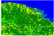
Nippes - Haïti - 2020, Land Cover Map at high spatial resolution
The map described here was produced as part of the Resilient Productive Territories (RPT) project. This project is funded by the World Bank. Reference of the database used to produce these maps: Dupuy, Stéphane; Lelong, Camille; Manasse, Marie Esther; Rambao, Jery; Mondésir, Jacques Philémon; Gaetano, Raffaele, 2021, "Nippes - Haïti - 2020, Reference Spatial Database", doi:10.18167/DVN1/29RZMQ , CIRAD Dataverse,V1
|
|
Citation proposal
. Nippes - Haïti - 2020, Land Cover Map at high spatial resolution. https://idg-tetis.teledetection.fr/geonetwork/srv/api/records/36618a22-1741-4299-94a3-3dbb75859db9 |
Simple
- Date ( Revision )
- 2022-05-17T19:10:07
- Edition
- 1.0
- Edition date
- 2015-01-01
- Identifier
- 36618a22-1741-4299-94a3-3dbb75859db9
Principal investigator
- Purpose
- The map described here was produced as part of the Resilient Productive Territories (RPT) project. This project is funded by the World Bank. Reference of the database used to produce these maps: Dupuy, Stéphane; Lelong, Camille; Manasse, Marie Esther; Rambao, Jery; Mondésir, Jacques Philémon; Gaetano, Raffaele, 2021, "Nippes - Haïti - 2020, Reference Spatial Database", doi:10.18167/DVN1/29RZMQ , CIRAD Dataverse,V1
- Status
- Completed
Principal investigator
- Maintenance and update frequency
- Not planned
- General ( Theme )
-
- Cartographie de l'occupation du sol
- Classification des sols
- Environnement
- Télédétection
- GEMET - INSPIRE themes, version 1.0 ( Theme )
- GEMET - Concepts ( Theme )
- GCMD Keywords viewer ( Theme )
- TETIS Thesaurus, version 1.0 21112019 ( Theme )
- Use limitation
- This work is licensed under a Creative Commons Attribution 4.0 License (CC BY 4.0, https://creativecommons.org/licenses/by/4.0 ).
- Access constraints
- License
- Use constraints
- License
- Classification
- Unclassified
- User note
- unclassified
- Classification system
- no classification in particular
- Handling description
- description
- Spatial representation type
- Vector
- Distance
- 200 m
- Metadata language
- English
- Character set
- UTF8
- Topic category
-
- Environment
- Imagery base maps earth cover
N
S
E
W
))
- Begin date
- 2020-01-01T00:00:00Z
- End date
- 2020-12-31T00:00:00Z
- Supplemental Information
- some additional information
- Reference system identifier
- EPSG / 2154
- Distribution format
-
- KML (1.0 )
- OnLine resource
- DOI
- Hierarchy level
- Dataset
Conformance result
- Alternate title
- This is is some data quality check report
- Date ( Publication )
- 2022-05-17T19:10:07
- Explanation
- some explanation about the conformance
- Pass
- true
Conformance result
- Date ( Publication )
- 2010-12-08T12:00:00
- Explanation
- See the referenced specification
- Pass
- true
Conformance result
- Date ( Publication )
- 2008-12-04T12:00:00
- Explanation
- See the referenced specification
- Pass
- true
- Statement
- The maps were produced with iota2 processing chain, developed in the framework of the activities of the "Land Use" Scientific Expertise Centre of the Theia Data and Services Center. They are distributed in raster TIFF format. IOTA2 produces land cover maps by classifying satellite images. It implies a time series of Sentinel 2 images a Digital Terrain Model, and a field reference database. This sheet therefore contains maps produced at each different precision level of the nomenclature:The most detailed level, labelled Code2, is composed of 12 classes. The basic level, labelled Code1, is composed of 8 classes. The level labelled Code0 is a proposal of slightly different distribution of classes at the same level than Code1. It is composed of 7 classes.A detailed report of the techniques used for the production of these maps is available (See below "Related Publication"). This report contains in particular the validation statistics of the maps, which quantify the global and by class validity of the results. (2021-03-23)
gmd:MD_Metadata
- File identifier
- 36618a22-1741-4299-94a3-3dbb75859db9 XML
- Metadata language
- English
- Character set
- UTF8
- Hierarchy level
- Dataset
- Date stamp
- 2022-05-17T19:30:02
- Metadata standard name
- ISO 19115:2003/19139
- Metadata standard version
- 1.0
Point of contact
Principal investigator
Publisher
Overviews
Carte Occ Sol Haiti
Provided by

Views
36618a22-1741-4299-94a3-3dbb75859db9
Access to the portal
Read here the full details and access to the data.
Associated resources
Not available