 IDG TETIS
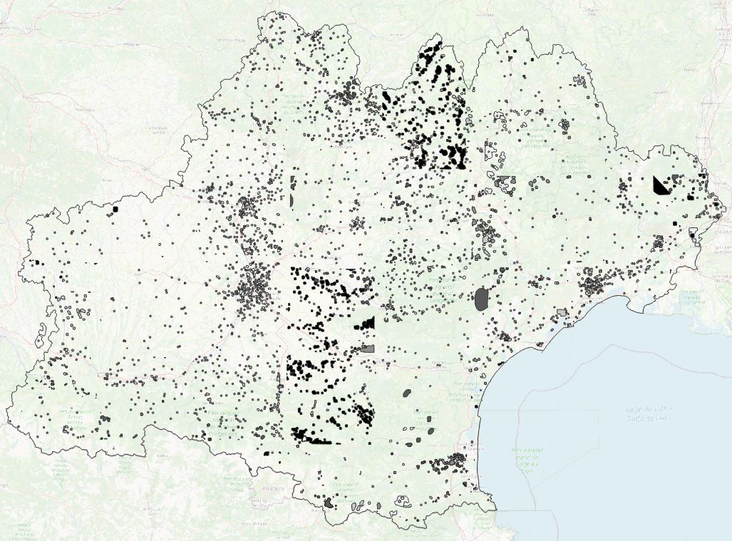
Projet Artisols -NoData SPOT 6/7 - Occitanie - 2015 à 2019
Les données de nodata par année (entre 2015 et 2019) correspondent aux zones de nuages et de leurs ombres portées sur les images satellites SPOT 6/7 utilisées pour la classification d'occupation du sol, donnée source pour les analyses géographiques qui ont suivi (extraction des espaces bâtis, des taches urbaines, indicateurs spatialisés)
|
|
Citation proposal
. Projet Artisols -NoData SPOT 6/7 - Occitanie - 2015 à 2019. https://idg-tetis.teledetection.fr/geonetwork/srv/api/records/6d7d3f3a-9f42-4d92-905d-2e5c111b7ff3 |
INSPIRE
Identification
- File identifier
- 6d7d3f3a-9f42-4d92-905d-2e5c111b7ff3 XML
- Hierarchy level
- Dataset
Online resource
- Protocol
- file for download
- Protocol
- OGC:WMS
Resource identifier
- code
- 6d7d3f3a-9f42-4d92-905d-2e5c111b7ff3
- Metadata language
- French
- Spatial representation type
- Vector
Encoding
- Format
- GPKG
- Version
- 1.0
Projection
- code
- 2154
Classification of data and services
- Topic category
-
- Imagery base maps earth cover
Classification of data and services
Coupled resource
Coupled resource
Classification of data and services
Coupled resource
Coupled resource
Keywords
- GEMET - INSPIRE themes, version 1.0 ( Theme )
- TETIS Thesaurus, version 1.0 21112019 ( Theme )
Other keywords
Geographic coverage
N
S
E
W
))
Temporal reference
Temporal extent
- Begin
- 2015-01-01T00:00:00Z
- End
- 2019-12-31T00:00:00Z
Temporal extent
- Date ( Revision )
- 2022-05-17T19:10:35
Quality and validity
- Lineage
- Les pixels de NoData ont été extraits de la classification finale des images satellitaires SPOT 6/7, et ce par année. Ils ont ensuite été vectorisés. Les polygones de cette couche finale sont associés, dans la table attributaire, à l'année correspondante à l'image satellitaire.
Conformity
Conformity
Conformity
Conformity
Conformity
Conformity
- Explanation
- some explanation about the conformance
- Explanation
- See the referenced specification
- Explanation
- See the referenced specification
Restrictions on access and use
Restrictions on access and use
Responsible organization (s)
Contact for the resource
- Organisation name
- INRAE - UMR TETIS
- eric.barbe@inrae.fr
Responsible organization (s)
Contact for the resource
- Organisation name
- INRAE - UMR TETIS
- eric.barbe@inrae.fr
Metadata information
Contact for the metadata
- Organisation name
- INRAE - UMR TETIS
- kenji.ose@inrae.fr
- Organisation name
- INRAE - UMR TETIS
- eric.barbe@inrae.fr
- Organisation name
- INRAE - UMR TETIS
- alexia.cornic@inrae.fr
- Organisation name
- INRAE - UMR TETIS
- kenji.ose@inrae.fr
- Organisation name
- INRAE - UMR TETIS
- alexia.cornic@inrae.fr
- Organisation name
- INRAE - UMR TETIS
- remi.cresson@inrae.fr
- Date stamp
- 2022-05-17T19:24:00
- Metadata language
- English
- Character set
- UTF8
SDS
Conformance class 1: invocable
Access Point URL
Endpoint URL
Technical specification
Conformance class 2: interoperable
Coordinate reference system
Quality of Service
Access constraints
Limitation
Use constraints
Limitation
Responsible custodian
Contact for the resource
Conformance class 3: harmonized
Overviews
NoData
Provided by

Views
6d7d3f3a-9f42-4d92-905d-2e5c111b7ff3
Access to the portal
Read here the full details and access to the data.
Associated resources
Not available