 IDG TETIS
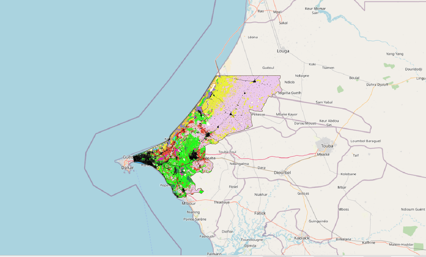
Cartographie de l'occupation du sol de la zone des Niayes (Sénégal) en 2018 (1.5 m de résolution)
La zone d'étude se situe au nord ouest du Sénégal et s'étale sur 5 100km². Elle inclue la ville de Thiès et une partie de la ville de Dakar, et remonte jusqu'à Kébémer, aux portes du désert de Loumpoul. La carte d'occupation 2018 a été réalisée à partir d'une image à Très Haute Résolution Spatiale (THRS) à 1.5m Spot6 acquise le 15/10/2010 et une série temporelle d'images Sentinel2 (résolution 10m) acquises entre le 01/01/2018 et le 31/12/2018. Le traitement a été réalisé via la chaine de traitement Moringa développée dans l'UMR TETIS. La méthodologie s'appuie sur une Segmentation Orientée Objet de l'image THRS puis d'une classification de chaque polygone (algorithme Random Forest) s'appuyant sur l'image SPOT6, la série temporelle Sentinel2, le SRTM à 30m et de nombreux indices calculés à partir de ces images (NDVI, indices de texture, pente,...). L’algorithme a été entrainé via un jeu de données acquises sur le terrain complété de données obtenues par photo-interprétation. Des corrections manuelles par photo-interprétation ont été réalisées afin d'améliorer le résultat. La précision globale est de 93%. La classification contient 13 classes d'occupation du sol : culture irriguée hors bas-fond, culture irriguée de bas-fond, culture pluviale, plantation, dune sable - arbustes, eau, savane arbustive, savane herbacée, sol nu, sol inondable, sol faiblement végétalisé, végétation naturelle dense et zone urbaine.
|
|
Citation proposal
. Cartographie de l'occupation du sol de la zone des Niayes (Sénégal) en 2018 (1.5 m de résolution). https://idg-tetis.teledetection.fr/geonetwork/srv/api/records/b1d9869a-934d-4b60-a48f-8ed8947e97a7 |
INSPIRE
Identification
- File identifier
- b1d9869a-934d-4b60-a48f-8ed8947e97a7 XML
- Hierarchy level
- Dataset
Online resource
- Protocol
- file for download
- Protocol
- OGC:WMS
Resource identifier
- code
- b1d9869a-934d-4b60-a48f-8ed8947e97a7
- Metadata language
- French
- Spatial representation type
- Grid
Encoding
- Format
- TIFF
- Version
- 1.0
Projection
- code
- 4326
Classification of data and services
- Topic category
-
- Environment
- Imagery base maps earth cover
Classification of data and services
Coupled resource
Coupled resource
Classification of data and services
Coupled resource
Coupled resource
Keywords
- General ( Theme )
-
- Cartographie de l'occupation du sol
- Classification des sols
- Télédétection
- Spot6/7
- Sentinel-2
- Environnement
- GEMET - INSPIRE themes, version 1.0 ( Theme )
- GEMET - Concepts ( Theme )
- GCMD Keywords viewer ( Theme )
- TETIS Thesaurus, version 1.0 21112019 ( Theme )
Other keywords
Geographic coverage
N
S
E
W
))
Temporal reference
Temporal extent
- Begin
- 2021-04-01T00:00:00Z
- End
- 2021-04-01T00:00:00Z
Temporal extent
- Date ( Revision )
- 2022-05-17T19:09:59
Quality and validity
- Lineage
- Cette carte a été produite avec la chaîne de traitement Moringa
- Distance
- 1.5 m
Conformity
Conformity
Conformity
Conformity
Conformity
Conformity
- Explanation
- some explanation about the conformance
- Explanation
- See the referenced specification
- Explanation
- See the referenced specification
Restrictions on access and use
Restrictions on access and use
Responsible organization (s)
Contact for the resource
- Organisation name
- CIRAD - UMR TETIS
- Audrey.Jolivot@cirad.fr
Responsible organization (s)
Contact for the resource
- Organisation name
- CIRAD - UMR TETIS
- Audrey.Jolivot@cirad.fr
Metadata information
Contact for the metadata
- Organisation name
- CIRAD - UMR TETIS
- Audrey.Jolivot@cirad.fr
- Organisation name
- CIRAD - UMR TETIS
- Audrey.Jolivot@cirad.fr
- Organisation name
- CIRAD - UMR TETIS
- Audrey.Jolivot@cirad.fr
- Date stamp
- 2022-05-23T19:12:24
- Metadata language
- English
- Character set
- UTF8
SDS
Conformance class 1: invocable
Access Point URL
Endpoint URL
Technical specification
Conformance class 2: interoperable
Coordinate reference system
Quality of Service
Access constraints
Limitation
Use constraints
Limitation
Responsible custodian
Contact for the resource
Conformance class 3: harmonized
Overviews
Carte Occ Sol Niayes
Provided by

Views
b1d9869a-934d-4b60-a48f-8ed8947e97a7
Access to the portal
Read here the full details and access to the data.
Associated resources
Not available