 IDG TETIS
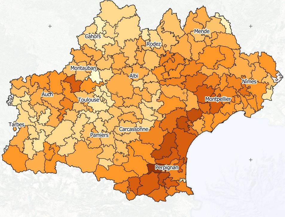
Projet Artisols - Indice de compacité des taches urbaines - 2019
Les taches urbaines distribuées sont caractérisées par des formes très variées. Ces formes peuvent aller d’un aspect très compacte (proche d’un disque, forme de compacité maximale sur un plan) à celui de formes très digitées ou de filaments, s’approchant de lignes plus ou moins sinueuses. Le suivi de cette dimension de compacité morphologique permet d’estimer si l’artificialisation due aux taches urbaines suit des extensions homogènes ou des extensions hétérogènes. Cet indice est calculé à l'échelle des EPCI d'Occitanie et pour l'année 2019.
|
|
Citation proposal
. Projet Artisols - Indice de compacité des taches urbaines - 2019. https://idg-tetis.teledetection.fr/geonetwork/srv/api/records/d137e590-f371-46ce-b139-82b48aadd6c3 |
INSPIRE
Identification
- File identifier
- d137e590-f371-46ce-b139-82b48aadd6c3 XML
- Hierarchy level
- Dataset
Online resource
- Protocol
- file for download
- Protocol
- OGC:WMS
Resource identifier
- code
- d137e590-f371-46ce-b139-82b48aadd6c3
- Metadata language
- French
- Spatial representation type
- Vector
Encoding
- Format
- GPKG
- Version
- 1.0
Projection
- code
- 27572
Classification of data and services
- Topic category
-
- Imagery base maps earth cover
Classification of data and services
Coupled resource
Coupled resource
Classification of data and services
Coupled resource
Coupled resource
Keywords
- General ( Theme )
-
- Urban sprawl
- GEMET - INSPIRE themes, version 1.0 ( Theme )
- TETIS Thesaurus, version 1.0 21112019 ( Theme )
Other keywords
Geographic coverage
N
S
E
W
))
Temporal reference
Temporal extent
- Begin
- 2019-01-01T00:00:00Z
- End
- 2019-12-31T00:00:00Z
Temporal extent
- Date ( Revision )
- 2022-05-17T19:10:31
Quality and validity
- Lineage
- Cet indice compare la surface d'une tache urbaine à la surface de son cercle circonscrit. Plus l'indice tend vers 1, plus la tache est compacte/circulaire. A l'inverse, plus il se rapproche de 0, plus la tache est digitée.Ici est proposé l’indice de remplissage discal correspondant au rapport entre la surface de la tache urbaine et celle de son cercle circonscrit, selon la formule suivante : Indice = A / π(Rcc)²Avec A : Aire de la tache urbaineRcc : Rayon du cercle circonscrit est la surface totale de l’unité territoriale de reportage.
Conformity
Conformity
Conformity
Conformity
Conformity
Conformity
- Explanation
- some explanation about the conformance
- Explanation
- See the referenced specification
- Explanation
- See the referenced specification
Restrictions on access and use
Restrictions on access and use
Responsible organization (s)
Contact for the resource
- Organisation name
- INRAE - UMR TETIS
- eric.barbe@inrae.fr
Responsible organization (s)
Contact for the resource
- Organisation name
- INRAE - UMR TETIS
- eric.barbe@inrae.fr
Metadata information
Contact for the metadata
- Organisation name
- AgroParisTech - UMR TETIS
- Organisation name
- INRAE - UMR TETIS
- eric.barbe@inrae.fr
- Organisation name
- INRAE - UMR TETIS
- alexia.cornic@inrae.fr
- Organisation name
- AgroParisTech - UMR TETIS
- Date stamp
- 2022-05-17T19:23:11
- Metadata language
- English
- Character set
- UTF8
SDS
Conformance class 1: invocable
Access Point URL
Endpoint URL
Technical specification
Conformance class 2: interoperable
Coordinate reference system
Quality of Service
Access constraints
Limitation
Use constraints
Limitation
Responsible custodian
Contact for the resource
Conformance class 3: harmonized
Overviews
Indice de compacité des taches artificialisées
Provided by

Views
d137e590-f371-46ce-b139-82b48aadd6c3
Access to the portal
Read here the full details and access to the data.
Associated resources
Not available