 IDG TETIS
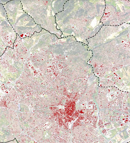
Projet Artisols - Espaces bâtis - Occitanie - 2015 à 2019
Les cartographies des espaces bâtis sur la région Occitanie résultent d'une extraction automatique par méthode d'apprentissage profond (deep learning) à partir d'imagerie très haute résolution spatiale (1.5m) SPOT 6/7, pour les années 2015 à 2019. Fichiers fournis sous forme vectorielle. (2021-09-09)
|
|
Citation proposal
. Projet Artisols - Espaces bâtis - Occitanie - 2015 à 2019. https://idg-tetis.teledetection.fr/geonetwork/srv/api/records/f0955d67-32b9-41f5-b584-bf13b9759ba7 |
INSPIRE
Identification
- File identifier
- f0955d67-32b9-41f5-b584-bf13b9759ba7 XML
- Hierarchy level
- Dataset
Online resource
- Protocol
- file for download
- Protocol
- OGC:WMS
Resource identifier
- code
- f0955d67-32b9-41f5-b584-bf13b9759ba7
- Metadata language
- French
- Spatial representation type
- Vector
Encoding
- Format
- GPKG
- Version
- 1.0
Projection
- code
- 2154
Classification of data and services
- Topic category
-
- Imagery base maps earth cover
Classification of data and services
Coupled resource
Coupled resource
Classification of data and services
Coupled resource
Coupled resource
Keywords
- General ( Theme )
-
- machine learning
- GEMET - INSPIRE themes, version 1.0 ( Theme )
- TETIS Thesaurus, version 1.0 21112019 ( Theme )
Other keywords
Geographic coverage
N
S
E
W
))
Temporal reference
Temporal extent
- Begin
- 2015-01-01T00:00:00Z
- End
- 2019-12-31T00:00:00Z
Temporal extent
- Date ( Revision )
- 2022-05-17T19:10:19
Quality and validity
- Lineage
- Basée sur des outils et méthodes d’intelligence artificielle, et plus précisément d’apprentissage profond (Deep Learning en anglais), une chaîne de traitement automatisée de classification a été finalisée afin de produire cette donnée. Elle a mobilisé 44 images satellitaires Spot 6/7 à très haute résolution spatiale (1.5 et 6 m) ainsi qu'un jeu de données de référence nécessaire à l’apprentissage et la validation des résultats. Afin de recouvrir de manière exhaustive le territoire d’Occitanie, soit environ 73 500 km², cette vérité terrain a été élaborée à partir de données d'occupation du sol d’OpenStreetMap et de données nationales délivrées par l’IGN (BD Topo®, BD Forêt®, OCS GE®, Registre Parcellaire Graphique®). Le réseau de neurones ainsi entraîné sur ces données terrain a ensuite été appliqué sur l'ensemble des images satellitaires (2015 à 2019). A l'issue de ce processus, tous les pixels des images ont été classifiés et nous disposons donc d'une carte d'occupation du sol. Seuls les bâtiments (classes "bâti résidentiel" et "bâti activité" de la nomenclature) ont ensuite été extraits afin d'obtenir la présente carte des espaces bâtis.
Conformity
Conformity
Conformity
Conformity
Conformity
Conformity
- Explanation
- some explanation about the conformance
- Explanation
- See the referenced specification
- Explanation
- See the referenced specification
Restrictions on access and use
Restrictions on access and use
Responsible organization (s)
Contact for the resource
- Organisation name
- INRAE - UMR TETIS
- eric.barbe@inrae.fr
Responsible organization (s)
Contact for the resource
- Organisation name
- INRAE - UMR TETIS
- eric.barbe@inrae.fr
Metadata information
Contact for the metadata
- Organisation name
- INRAE - UMR TETIS
- kenji.ose@inrae.fr
- Organisation name
- INRAE - UMR TETIS
- eric.barbe@inrae.fr
- Organisation name
- INRAE - UMR TETIS
- alexia.cornic@inrae.fr
- Organisation name
- INRAE - UMR TETIS
- remi.cresson@inrae.fr
- Organisation name
- INRAE - UMR TETIS
- kenji.ose@inrae.fr
- Organisation name
- INRAE - UMR TETIS
- alexia.cornic@inrae.fr
- Date stamp
- 2022-05-17T19:21:21
- Metadata language
- English
- Character set
- UTF8
SDS
Conformance class 1: invocable
Access Point URL
Endpoint URL
Technical specification
Conformance class 2: interoperable
Coordinate reference system
Quality of Service
Access constraints
Limitation
Use constraints
Limitation
Responsible custodian
Contact for the resource
Conformance class 3: harmonized
Overviews
Espaces bâtis
Provided by

Views
f0955d67-32b9-41f5-b584-bf13b9759ba7
Access to the portal
Read here the full details and access to the data.
Associated resources
Not available